

Lookout Mountain is an amazing place to discover nature, history and enjoy vistas reaching out to a claimed seven states. The Mountain is best explored on foot along its myriad of trails traversing the dense forest slopes of this quintessential Appalachian prominence. Surrounded to the north, east and on top by urbanity, it is easy to forget you are never far from civilization if not for the subtle roar of traffic on Interstate 24 far below.
CUMBERLAND PLATEAU
Most of the mountain lies in Georgia with only the northeastern end lying across state borders into Tennessee. Geologically, Lookout Mountain is part of the Cumberland Plateau, a deeply dissected plateau with a ridgeline extending southwestward into Alabama, interrupted by Big Wills Creek at the town of Attala, for over sixty miles. Past the Big Wills Gap, ridges continue, sometimes intermingling, farther south past Birmingham pushing a hundred miles or more. That said, the west edge of the mountain begins to divide into disparate ridges south of Trenton, Georgia where Interstate 59 takes advantage of a gap at Rising Fawn. Another complex of ridges extends further east mixing with other ridges like Pigeon Mountain near Lafayette.


But here, our concentration centers upon the northernmost three to four miles of the mountain before its spectacular drop down to the Tennessee River opposite Moccasin Bend. To the south, the mountain top opens into a plateau which extends up to a mile across in the far south, coming to a point in the north at the appropriately named Point Park.
Lookout Mountain makes up part of the southern border of the Cumberland Plateau on its eastern rim. Made of limestone and shale, there are several caves to find and explore. The mountain is covered with hardwood deciduous forests, especially on the steep slopes found on the west and east slopes of the mountain. It is within these forests an extensive trail system exists, mainly within the boundaries of the Chickamauga & Chattanooga National Military Park on the northern end of Lookout Mountain.
MODERN HISTORY

Several of these trails approximate the route taken by Federal troops on 24 November 1863. They drove Confederate soldiers off the western slopes that day. Wheeling around the northern point of the mountain at Cravens Terrace, the Union men threatened to isolate the Confederate division of Carter Stevenson on top of the mountain. They threatened the only road link to the summit plain, Summerland Road. With the threat, Braxton Bragg gave up Lookout Mountain. He ordered Stevenson’s men to reinforce the main Rebel line atop Missionary Ridge to the east of Chattanooga.
The forested slopes on either side of the top of Lookout Mountain stand protected by the National Park thanks in part to the efforts led by Adolph Ochs. During the late 19th and early 20th centuries, local businessmen began to develop tourist spots on the mountain effectively drawing many to witness historic and natural wonders of the mountain. If those were not enough, they began to “improve” upon the natural beauty or create entirely new “wonders”.
TOURISM ON THE MOUNTAIN IN THE LATER 19TH CENTURY
There were two distinctive periods in the development of tourism atop Lookout Mountain. The late 19th century involved the richest woman in the South, Harriet Lenora Straw Whiteside. Her husband, James A. Whiteside, moved to the area of Ross’s Landing – the original site being below the current commercial development of Ruby Falls – on the Tennessee River below the northern point of Lookout Mountain. He moved his family into a two-story brickhouse on what became eventually known as Cameron Hill.
THE COLONEL

Given the honorific title of “Colonel” somewhere along the line, Whiteside, a lawyer, and state politician, became an investor and proponent for railroads. His influenced helped select the new town of Chattanooga as the northern end of the Western & Atlantic Railroad connecting to Atlanta where other railroads served to expand the Georgian transportation system onward to seaports. The Whiteside family moved to Nashville in late 1857 so the Colonel could better help with the development of the Nashville & Chattanooga Railroad, Tennessee’s first complete rail system.
The N&C line helped connect Chattanooga making it an important transshipment stop. He was instrumental in getting the Memphis & Charleston Railroad to run through Chattanooga. Two other railroads targeted Chattanooga as a destination, the East Tennessee, Virginia & Georgia Railroad and the Wills’ Valley Railroad, today’s Alabama Great Southern – which did not reach Chattanooga until after the Civil War.
THE COLONEL AND THE MOUNTAIN
The Whitesides retained their home on Cameron Hill as well as a home on top of Lookout Mountain as a summer residence. Owning much of the land on the mountain, he hoped to attract wealthy Southerners to build their summer residences there, as well as to escape the problems of yellow fever and malaria. The community of Summertown was the result of his real estate venture at the time of the Civil War. A road – the Whiteside Turnpike – served as the only road leading up to the top of the mountain. Some of the remains of the historic turnpike can be hiked through the slopes leading up the eastern slopes – Whiteside Trail. Access for this trail is off the Guild Trail – this trail traverses the slopes of Lookout Mountain from Ruby Falls to the north around the east side to the Guild-Hardy Trailhead on Ochs Highway – Tennessee Route 58.
In 1857, the Colonel began the erection of a hotel on the east rim of the mountain above Lenora Spring. Twenty-five cottages comprised his new community atop the Whiteside Pike. The hotel was the first “Lookout Mountain Hotel” opening the following year for guests. Horse stages brought people up from Chattanooga daily. The turnpike had been incorporated in 1852 with a toll charged for access. There is a historical marker next to a new house probably larger than the size of the old hotel at the intersection of Sunset Road East and East Brow Road denoting the original site of Summertown and the hotel.
JAMES CAMERON

A famous painting of the Colonel and his second wife, Harriet, relaxing with Moccasin Bend in the background stands in the Hunter Museum down on the waterfront in Chattanooga. The painting, a gift from Scottish painter James Cameron. Whiteside enjoyed Cameron’s work so much he gave him a place to live – Cameron Hill in Chattanooga is named after the painter. This was an area frequented by affluent members of the town including both Whiteside and Adolph Ochs. It was totally transformed in the 1950’s by freeway construction and urban development.
Cameron, as an aside, moved away from Chattanooga to Philadelphia where he had lived earlier in 1863 realizing the war made it impossible for him to work. Returning after the war to find Chattanooga devasted with no possible art commissions on the horizon, he and his wife moved to California becoming a Presbyterian minister in Oakland. He died in 1882 when his wife mistakenly gave him a dose of carbolic acid instead of medicine he was taking for a bone abscess in the foot.
The Colonel died in the first year of the Civil War when he traveled north to Virginia to see about his son James who, while enlisted as a soldier with the 1st Tennessee, had become seriously ill. James would survive, but the journey weighed hard on the father who succumbed to illness 12 November 1861.
Enter the wife

The Colonel married twice. His first wife, Mary Jane Massengale, died after giving him five children 12 April 1843. He then married Harriet, whom he had brought in previously to teach piano to his children, the following year on 1 February 1844. With Harriet, the Colonel had nine more children. He left a fortune in land, railroad stock and mines to his 36-year-old wife who shared with the children. She had just arranged his husband’s affairs when Braxton Bragg occupied Chattanooga.
Harriet was still in Chattanooga at the time of the battle of Missionary Ridge. She changed her Confederate money into tobacco selling it for federal greenback money invested by a friend. The investments returned enough money to send two of her daughters to school in New England in 1864. She led an effort to bring mattresses into town for wounded soldiers after the battles helping the wounded and dying.
However, Harriet and the five children remaining at home were deported to Springfield, Ohio in July 1864 given only 24 hours’ notice. She returned to Chattanooga only in June 1865. She found Federal officers residing in her house – hit by over 50 shells during the siege. One of her children came down with a case of the chicken pox. The officers moved out after she posted a sign noting “small pox”.
BATTLE OF THE MOUNTAIN ROADS
Here we start the real Battle of the Mountain, known as the “Battle of the Mountain Roads”/. Over the next twenty years, she fought to regain lands lost during the war using the best lawyers Chattanooga had. One of those, Varney Gaskill, a Vermonter who moved to the South before the war, whom she married in the mid-1870s.

As the South slowly recovered from the war, traffic began to increase going up the Whiteside Pike, especially in 1878 with a yellow fever epidemic. Complaints rose over the increase in tolls on the pike and the greed of Madam Whiteside nee Gaskill. Suits ensued with the development of a rival road – the St. Elmo Pike – and Gaskill represented his wife. Losing the case in court. Harriet began to charge her new husband for rent in his own house. That was followed by a bitter divorce which was granted in the summer of 1879 with Gaskill ordered to pay for costs.

The opposing group included her own son-in-law, and their road is the Ochs Highway today. Harriet began denying access to the Point for visitors completely fencing off her property with armed guards patrolling. The lawsuits and militarization of her property turned public opinion strongly against her.
POINT HOTEL AND INCLINE #1

To get around her stranglehold on the mountain, investors, in 1885, constructed Incline Railroad #1. This ran from St. Elmo, the community at the bottom of the mountain on the east side along Chattanooga Creek, around the bluff on the Point to a place where three years later, the Lookout Mountain Point Hotel went up. With four stories and wrap-around porches, visitors could once again enjoy, for a fee, the views offered from the Point denied by Harriet.

The Point Hotel gave visitors 58 rooms to enjoy the views from. Harriet, however, was not amused. She had a staircase leading up to the Point removed so visitors could not easily access the top of the mountain. To access the hotel, the 4,360-foot-long steam-powered Incline #1 wound up from the east side of the mountain – the railbeds serve as trails today. The narrow-gauge line extended further south to Sunset Rock. Visitors could come for the day – with dinner at the hotel the cost would be $3 – or stay the night. Visitors included President Theodore Roosevelt in 1902.

The railway transformed to electric for awhile before it went out of business due to competition from the newer Incline #2 railway – which still runs today. The Hotel then followed, burning and then demolished just before 1920. A small plaque exists at the bottom of the steps leading down from Roper’s Rock from Point Park. Look carefully and you can discern the flat area where the train used to park at the hotel.
QUIETLY INTO THE NIGHT?

Harriet sold her Lookout Mountain property in 1887. Not one to go quietly into the night, she financed the development of Incline #2 in 1895. The War of the Mountain Roads came to an end in 1898. The federal government stepped in and bought the land around the slopes of Lookout Mountain, including the area making up Point Park today.
20TH CENTURY – BUILD IT AND THEY WILL COME
For the sake of completeness, I want to concentrate on the northern end of Lookout Mountain. Here, several features built in the early 20th century aimed at increasing the flow of tourists to the top of Lookout Mountain.
MORE HOTELS

First, though, there was still the Incline #2 pulling visitors up to the top of the mountain. The Lookout Mountain Inn sat just across the street. This huge hotel opened 2 June 1890. Like most hotels – and for quite some time, cottages up here, too – were open only seasonally from late May or early June. In order to remain solvent, the season eventually expanded to include the whole year. A casino and billiard hall were added to keep guests occupied when they were not outside taking in the views.


The Lookout Inn burned down 17 November 1908. A little park now stands partly where the old dowager used to greet people. Before it burned down, the Inn played host to a bevy of VIPs including Theodore Roosevelt, Grover Cleveland, William McKinley, Prince Henry of Prussia – the younger brother of Wilhelm. As a competitor of the Point Hotel, Mrs. Whiteside was only too happy to invest in the Lookout Inn.

In 1928, a little further south, across the border in Georgia on the west rim, the Lookout Mountain Hotel. The hotel was built with 200 rooms for guests and the largest ballroom in the South. The nickname given to the hotel was “The Castle in the Clouds”. That hotel survives today as Carter Hall, part of the Covenant College campus.
FAIRYLAND, TOM THUMB AND ROCK CITY

Just one of several tourist attractions built on Lookout Mountain around the same time era. Roads gained pavement to the top in 1927. Fairyland Inn was built in 1925 at the behest of Garnet Carter. He developed 700 acres atop the mountain as a resort community. Building Fairyland Inn was the cornerstone of his plans around which he hoped to erect an 18-hole golf course. The golf course did not go in so fast.

Carter figured guests needed extra diversions to keep them at the hotel. So, he built a miniature golf course which encompassed various obstacles with gnomes and other fairytale personas watching on. He patented the idea under the name Tom Thumb Golf. There were 25,000 miniature golf courses across the US by 1930.
rock city

Carter sold his Tom Thumb courses. He put the money into the development of the other nearby large creation of Rock City Gardens. The original Tom Thumb course taken out to enlarge the entry driveway. Some vestiges of the old course do remain around the Inn. The Inn remains a busy place today with membership including the nearby golf course which eventually got built. The surrounding 450-acre residential community is known as Fairyland.
A big chuck of land atop the east rim to the south of Fairyland became developed into a huge rock garden. Paths led between giant rock formations planted with wildflowers and festooned with imported German gnomes. A huge man-made waterfall added, with a variety of other attractions added over time. Add that to a very ambitious advertising campaign. One sees “Visit Rock City” painted on barns or roadside signs for many miles outside of Chattanooga in all directions. Here, a case of build it and they will come.
RUBY FALLS
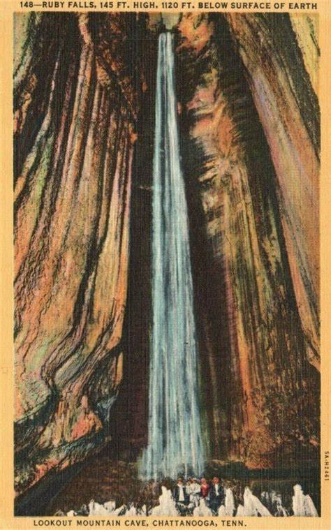
The other big tourist attraction is back at the northern base of Lookout Mountain, Ruby Falls. Limestone – of which on Lookout Mountain, there is plenty – and water do not mix well over centuries. Cracks form where limestone slowly dissolves. Cracks can lead to caves of which several exist on the mountain. One of the best and longest known was Lookout Mountain Cave. While this cave opens to the outside, another cave, Ruby Falls, does not. It was discovered in 1928.
Cave enthusiast and chemist Leo Lambert hoped to re-open the Lookout Mountain Cave in the 1920s after rail tunnel construction had blocked the original entrance. Working from above, planning on using an elevator to reach the cave, he reached a new cave. Digging further, the original cave was reached and both caves were opened. With the popularity of Ruby Falls Cave – Ruby was Lambert’s wife – because of the secret waterfall, the lower cave stood blocked off by 1935 as tourists concentrated on the upper cave. The cave added electric lights as one of the first tourist caves to feature lighting.
LOOKOUT MOUNTAIN VISITOR CENTER

Across the street from the crenellated entrance to Point Park is a small Visitor Center focusing mainly upon the Civil War actions on Lookout Mountain. The main feature of the center is the magnificent battle panorama painted by James Walker for Major General Joseph Hooker in 1874. Measuring 13 by 30 feet, the painting was Walker’s largest costing Hooker $20,000 – over $540,000 in today’s dollars. It helped Hooker in marrying well.

The painting eventually became displayed in several different cities across the country. In 1913 the painting was rolled up and stored until 1957 when the painting was donated to the NPS. However, it was not until 1985 when funds became available to restore the painting and install it in the present location.
There are several free parking spaces available behind the Visitor Center where you can also park if you are off on the trails of Point Park or beyond. Otherwise, street parking is metered. Alternatively, you can ride up – and down – on the Incline Railway whose upper terminus is a five-minute walk to the south along East Brow Road.
POINT PARK

Sitting on the northern tip of the summit plateau of Lookout Mountain is the 16-acre Point Park. Ten acres occupy the southern grassy plain ringed by a wide promenade with wide encompassing views out over Chattanooga and the countryside to the west, north and east. Throw in a few cannons to represent the former Confederate batteries occupying the heights before 24 November 1863 and the tall New York Peace Memorial rising near the northern end and you have a gorgeous park to sit out and take in the world from.
CANNONS GALORE

The upper ten acres is flat representing the northernmost extension of the Lookout Mountain plateau. Entrance goes through a large castle-like gate modeled after the Army Corps of Engineers insignia. Paths feature two great overlooks looking east and northeast over the city of Chattanooga. There are three sets of cannons noting Confederate gun battery emplacements atop the mountain before 25 November 1863 – Corput’s Georgia Battery – accounts for two of the three with one section facing Chattanooga and the other pointed over Lookout Valley to the west – and Garrity’s Alabama Battery.


There is also a tablet describing the positioning of Carter Stevenson’s division atop Lookout Mountain. Federal forces routed Confederate defenders on the western slopes of the mountain and on the north plateau where Cravens House was. In doing so, they threatened Stevenson’s division by cutting off the lone road to the top connecting to Summerland. With the defeat of 24 November, Bragg ordered Stevenson off the mountain to rejoin the main forces to the east on Missionary Ridge. You can find more of Stevenson’s tablets over there along Crest Road. With Stevenson gone, Federal forces – 8th Kentucky and the 96th Illinois – occupied the top of the mountain the next day.
Entrance to Point Park is $10, payable at a machine next to the entrance.
Ochs’s Observatory

To the immediate north of the main area of Point Park, stairs lead down on the west side to a lower subsection of the plateau on which the northernmost point Ochs Observatory and Museum is located. Originally developed in the late 1930s, money problems slowed the project until it finally opened in 1940. This became the main center for visitors to gain an overview of all of the park battlefields with temporary exhibits installed and four battlefield maps plus an exhibit dealing with the Tennessee Valley Authority outside. Shortly after World War 2, the main interpretation for the battlefields switched to the Administration Building – today’s Visitor Center – at Chickamauga on Lafayette Road.

The exhibits today in the little museum rooms act as a ‘branch museum” to both the main Visitor Center at Chickamauga and the little Visitor Center across the street from the entrance to Point Park.
The observation-museum complex honors Adolph Ochs, a longtime publisher, first in Chattanooga and then with the New York Times. Ochs served as a prime mover in the development of the Lookout Mountain section of the Chickamauga and Chattanooga National Military Park. The complex went up on the site of the Linn brothers’ photographic studio. Their pictures of soldiers and everyday visitors to the top of Lookout Mountain either on Roper’s Rock or Umbrella Rock are classics. The NPS, out of safety reasons, only allow people to scamper up on Umbrella Rock today for fundraisers.
TRAIL SYSTEM
POINT PARK TO CRAVENS HOUSE

The Chattanooga Tourism Co. has a list of the “6 Best Hikes on Lookout Mountain”. Several of them either start at Point Park or below at Cravens House. Thanks in large part to Adolph Ochs, much of the slopes of Lookout Mountain remain preserved within the boundaries of the National Military Park. An extensive trail system has developed allowing hikers miles of opportunities to wander through the hardwood forests of the mountain’s slopes.

By far the main trail is the path leading down from Och’s Observatory to the Cravens House. Coming from Point Park, you descend on a series of metal stairs beneath the summit cliffs. From the bottom of the stairs, you can walk to the right which becomes the upper part of the Mountain Beautiful Trail. That trail leads to a trail dropping in a couple of switchbacks down to the Federal regimental monuments in the woods above the Cravens House.
RAILS TO TRAILS

Alternatively, turn left at the bottom of the stairs – check out first, the plaques fixed to the summit cliffs memorializing a couple of Pennsylvanian regiments of Colonel George Cobham, Jr. The path goes over the former railbed used by Incline#1 leading up to the Point Hotel. You can see the wide point where the single rail became double at the former hotel site.
OTHER WAYS THROUGH THE FORESTS


The trail – Bluff Trail – continues all the way to Sunset Rock – 1.38 miles – and beyond to Ochs Gateway at Covenant College – 4.3 miles. The rail line used to extend as far as Sunset Rock. After 0.52 miles turn right onto Cravens House Trail which drops down along the old Incline rail path to Cravens House for another 0.52 miles. Cravens House was the main site of fighting on 24 November 1863. There are three tall State monuments – Iowa, New York, Ohio – plus a bevy of regimental monuments and tablets both next close to the Cravens House but also in the woods above. The Rifle Pits Trail, intersected just before reaching the Cravens House, runs downhill in the approximate route taken by Federal troops as they flanked Confederate positions set up to face potential enemy coming straight up the mountain slopes.

Take a good look at the trail map and set up your own loops withing the forests of Lookout Mountain. The best time of year to visit is late winter-early Spring or mid to late Fall when the leaves are gone. Winter can also be a good time to walk given a break in the weather – the battles up here, after all, took place at the end of November.
Figure two-three hours hiking from between Cravens House and Point Park. Remember the $10 charge for Point Park which exists for hikers coming up from below, as well – there is no charge for visits to the Cravens House.